
The True Size of Africa
Notice: Test mode is enabled. While in test mode no live donations are processed.

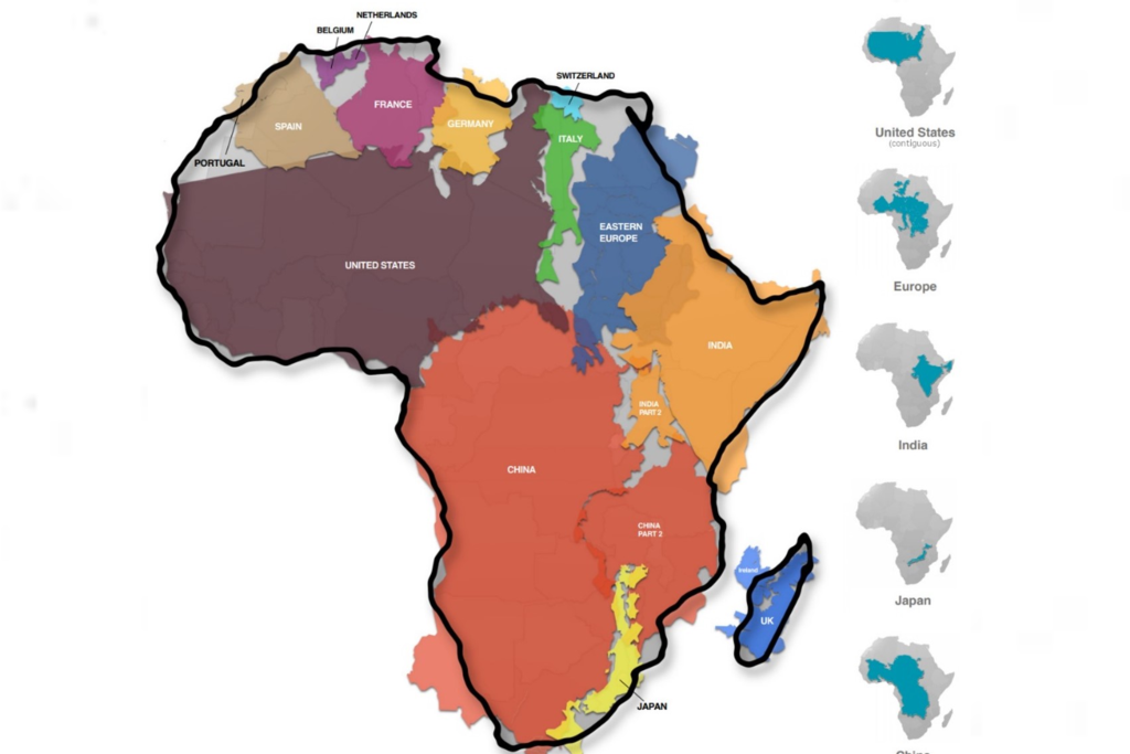
This site must begin by putting its subject in the right perspective. Most people know that Africa is a very large landmass, but are not aware that the continent’s true size has been vastly underestimated. This is because most “Western maps” use the Mercator projection, which makes Africa, like other landmasses near the Equator, appear very small, whereas landmasses near the poles are inflated in size. In the illustration below, the inflated sizes of countries is depicted in light blue, while their true sizes is depicted in dark blue.

Although it was originally created for 16th-century sea captains, “the Mercator map has become the de facto standard for world mapping…used from geography textbooks to Google Maps, and it is the only way most people recognise the position and size of the Earth’s countries and continents.” However, the Mercator map “distorts the relative size of the continents, to the advantage of the West, to which it gives undue prominence by pumping up the sizes of Europe and North America.”
“Drawn in 1569 by the Flemish cartographer, Geert de Kremer (also known as Gerardus Mercator), the map became popular because Mercator decided on drawing a planisphere, which represented the meridians and parallels as straight lines that cross at right angles, and thus preserved local angular relationships, thereby helping sailors to navigate the world’s oceans.”
For instance, the world’s largest island, Greenland, is projected as being the same size as Africa, but in reality, Africa is 14 times larger. Russia and Canada also appear to comprise about 25% of the Earth’s landmass, but they in fact, occupy a mere 5%. While Africa’s size is shrunk on the Mercator map, Canada appears a lot bigger than Africa, but in fact, three Canadas would comfortably fit inside Africa. Russia’s size is also exaggerated, and it appears bigger than Africa, while in reality, Africa is almost twice the size of Russia.

As shown above, Africa is in fact very big, measuring 30.37 million square km (or 11.73 million square miles), which is bigger than the United States, Canada and China put together. The great misrepresentation of this geographic reality has led to the false Eurocentric world we see today, “with great implications for global politics and economics, and negative consequences for regions like Africa.”
Cited in: Ankomah, B. (ed). (2020). The Africa Factbook: Busting the Myths. Institute of African Knowledge (INSTAK). Published by the Book of African Records (BAR) in partnership with the African Union Commission (AUC). Printed in South Africa